Evergreen Point

Eastside Stories: Ferry Landings of Lake Washington--Part II

No. 8 | May 15, 2019

Eastside Stories

Ferry Landings of Lake Washington--Part II

Eastside Stories is our way of sharing Eastside history through the many events, people places and interesting bits of information that we collect at the Eastside Heritage Center. We hope you enjoy these stories and share them with friends and famil…

Eastside Stories is our way of sharing Eastside history through the many events, people places and interesting bits of information that we collect at the Eastside Heritage Center. We hope you enjoy these stories and share them with friends and family.

In the first part of our tour of ferry landings on the east side of Lake Washington we covered the north part of the lake, from Juanita to Hunts Point. Now we will pick up the story continuing around the Points.

For the most part, the public ferry docks and wharves were built and maintained by King County. Except for Kirkland, which became a city in 1905, the eastern shore of the lake was all unincorporated and county government was the default provider of local government services and infrastructure.

When a group of settlers decided they needed a road or ferry dock they would petition the County Commission and make their case for the investment. If the county agreed to build the facility, property owners would be required to donate the necessary land. Roads were usually unpaved at first, and residents would have to undertake the entire process again to get a road widened and paved.

Periodically the county would send out an intrepid engineer to inspect the ferry docks. The logbooks for these inspections are in the King County Archives and provide insight into the challenges of maintaining these critical links. At a time when treated lumber was a rarity, there were perennial problems with rot and dangerous conditions.

And as ferry service declined and then ended, the county was left with a collection of mostly decrepit piers that had been gradually adapted to public uses.

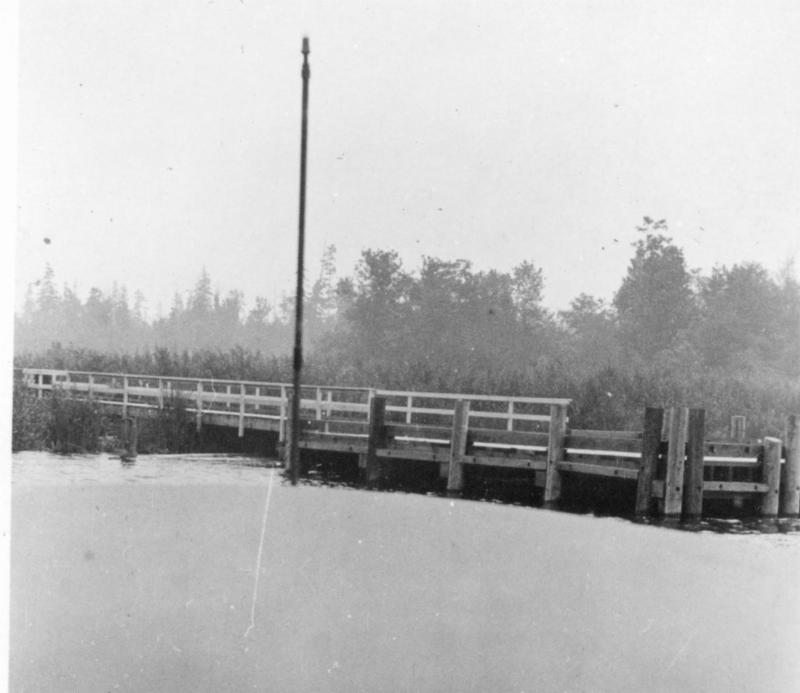
Fairweather Wharf. We'll begin just south of where we left off in Fairweather Bay, between Hunts and Evergreen points, with the strange case of the Fairweather Wharf. Where today there is an engineered yacht basin between the two points, there was originally a wetland. In 1918, after Lake Washington was lowered and the wetland more fully exposed, King County decided that a wharf was needed at this location. This required construction of an elaborate structure--the Boddy-Hindle Trestle--across the wetland, with a spur to the wharf.

While the Boddy-Hindle Trestle became an important route through the Points, linking Evergreen Point to the base of Hunts Point, where there was a school and market, the wharf was never much used. No one lived in the immediate area and more convenient wharves were available on the points.

The image shows Fairweather Wharf when it was relatively new, with the section to the left leading to the Boddy-Hindle Trestle. A wharf inspector's report from 1930 indicates that the wharf is badly rotted and that everything above the water needed replacing. An inspector's report from 1946 indicates that the wharf had completely disappeared and no sign of it remained. The inspector was not bothered, though, noting that the wharf "was in a location not suitable for any reasonable construction supported by piling or otherwise."

304-jpg.jpg

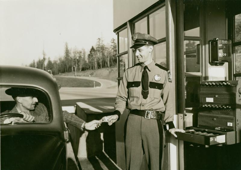
Evergreen Point-Lake Lane . This pier served Evergreen Point and was a regular stop for the steamer Ariel. Its origin seems somewhat uncertain, as the Wharf Inspector of 1946 cannot find records of it having been built by King County. By 1946 ferry service had ended and the inspector noted that the pier was used for public access to the lake for swimming and boating--activities of which he approved! This location remains a public dock maintained by the City of Medina. (Photo courtesy of Washington State Archives)

Old Medina Dock-jpg.jpg

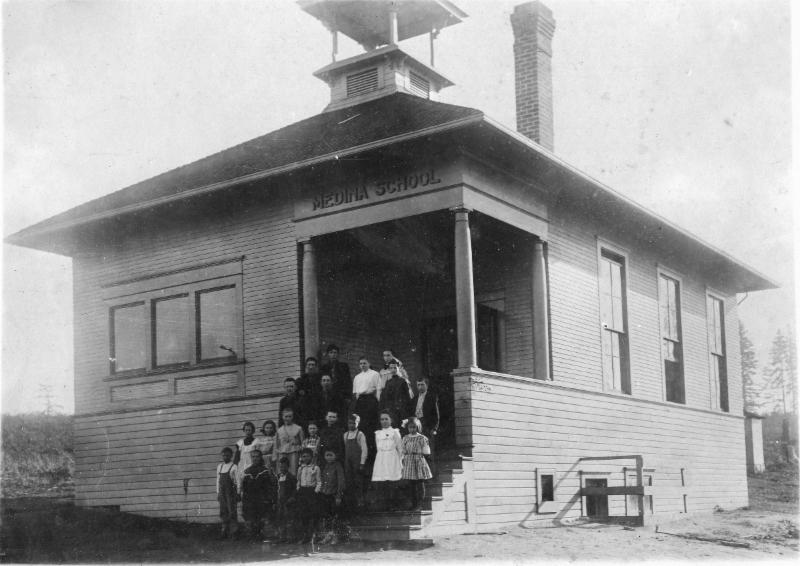
Original Medina dock . Medina enjoyed regular ferry service from Seattle as early as the 1890s, with this robust pier at the foot of what is today N.E. 8th Street, near the "Green Store" and post office. The lakefront land for the wharf was donated to the county by Thomas Dabney, one of the first residents of the area. When a new car ferry landing was built to the south, the new owner of the Dabney property, Captain Elias Johnston, went to great lengths to reclaim the land from the county.

Old Medina car jpg.jpg

First Medina car ferry landing . The Port of Seattle introduced car ferry service to Medina and Bellevue in 1913, and this was the original wharf at the foot of Evergreen Point Road. This pier was left high and dry just a few years later when Lake Washington was lowered by nine feet with the opening of the new Ship Canal. The identity of the child on the beach is not known.

Medina ferry dock 1937-jpg2.jpg

Medina Ferry Terminal . Following the lowering of Lake Washington and the exposure of new shoreline, King County built a new car ferry dock and terminal building. The original dock was built immediately adjacent to the terminal building and later moved to the south as shown in this image. When ferry service ended, the terminal building became a community clubhouse and, later, Medina City Hall. A much-remodeled city hall and beach park remain on the site today.

clyde wharf 1908-jpg.jpg

Clyde landing, Meydenbauer Bay, Bellevue. This pier stood at the foot of Clyde Road (now 92nd Avenue NE), which was named by an early resident with Scottish roots. It is not clear how much ferry service was provided to this location, as it is close to the main Bellevue dock. But the property did remain in public ownership and was converted into Clyde Beach Park, which is maintained by the City of Bellevue.


Learn more about the Eastside. Books available from Eastside Heritage Center include:

Lake Washington: The Eastside

Bellevue: the Post World War II Years

Our Town, Redmond

Medina

Hunts Point

Bellevue: Its First 100 Years


Our Mission To steward Eastside history by actively collecting, preserving, and interpreting documents and artifacts, and by promoting public involvement in and appreciation of this heritage through educational programming and community outreach.

Our Vision To be the leading organization that enhances community identity through the preservation and stewardship of the Eastside’s history.


Eastside Heritage Center is supported by 4 Culture

Eastside Heritage Center is supported by 4 Culture

Eastside Stories: Eastsiders Pay the Toll

No. 7 | May 1, 2019

Eastside Stories

Eastsiders Pay the Toll

Eastside Stories is our way of sharing Eastside history through the many events, people places and interesting bits of information that we collect at the Eastside Heritage Center. We hope you enjoy these stories and share them with friends and famil…

Eastside Stories is our way of sharing Eastside history through the many events, people places and interesting bits of information that we collect at the Eastside Heritage Center. We hope you enjoy these stories and share them with friends and family.

When tolls made their reappearance on the Evergreen Point floating bridge in 2011, many commuters traveling to and from the Eastside were not happy. But this was really a return to the historic norm: for most of Eastside history, it has cost something to take a car across Lake Washington.

All the early passenger steamers charged a fare, of course, and with the introduction of car ferries to Kirkland, and then to Bellevue and Medina, cars could cross the lake at a price. A ferry schedule for both routes from 1930 shows a fare of 50 cents one way and 75 cents round-trip for “light cars” and 60 cents one way and 90 cents round-trip for “heavy cars,” the cut-off point between light and heavy being 2,600 pounds. 

The Seattle-Medina ferry came to an end in 1940 when the new floating bridge opened between Mercer Island and Seattle. And as with most major bridge projects funded by state bond issues, it came with tolls. The toll plaza was located at the first turn onto Mercer Island from the floating bridge, and the toll was set at 25 cents for the car and driver, and another five cents for each passenger. The state removed the tolls when the bonds were retired in 1949.

The new bridge offered a much faster trip across the lake, and one at half the fare. The loss of the ferry turned Medina into a bit of a backwater, and the the new bridge raised the profile of the sleepy village of Bellevue.

A cheerful toll collector greets a driver heading across Mercer Island to Seattle in 1940.

A cheerful toll collector greets a driver heading across Mercer Island to Seattle in 1940.

By the mid-1950s, when the massive developments at Lake Hills, Eastgate and Newport Hills began to lure families “over the bridge and to a new way of living,” there were no tolls on the Mercer Island bridge and the commute to Seattle was an easy one.

By the late 1940s, as the Mercer Island bridge was filling up faster than planned, thoughts of a new bridge began to bubble up among Eastside leaders. Meanwhile, on the other side of the country, Congress was hashing out the National Interstate and Defense Highways Act that provided 90 percent of the funding for a national network of freeways.

States could keep tolls on existing bridges and turnpikes that were incorporated into the new Interstate network, but newly built Interstate freeways were supposed to be toll-free: Interstate 90 across Mercer Island would never have tolls, even on the new and very expensive bridge that opened in 1989.

 
Toll plaza on Mercer Island, looking across Lake Washington to Seattle

Toll plaza on Mercer Island, looking across Lake Washington to Seattle

The same could not be said for the new SR-520 corridor planned from Seattle to Redmond. It would not be part of the Interstate system and would need to be funded in-state. So, once again, tolls entered the picture. The new Evergreen Point Bridge, opened in 1963, had a toll plaza in Medina and collected 35 cents per car, with no extra toll for passengers. Commuters could purchase books of tickets that cost about 19 cents each. To encourage ridesharing during the energy crisis of the 1970s, tolls were reduced to 10 cents for cars with two or more passengers.

 
Toll plaza for the Evergreen Point bridge in Medina

Toll plaza for the Evergreen Point bridge in Medina

The ticket books led to one of the more curious criminal enterprises in Eastside history. In the early 1970s, a group of toll collectors began to purchase those 19 cent tickets and swap them for the 35 cent cash tolls they collected, which then went into their pockets. Over time, these 16 cent “profits” added up to many thousands of dollars. The perpetrators were eventually caught and a number of well-known faces in the tollbooths disappeared.

As with the bridge over Mercer Island, traffic volumes on SR-520 exceeded expectations and the state retired the construction bond early. Tolls came off the bridge in June of 1979.

It took some significant changes in state law to return tolls to the original SR-520 bridge in order to fund the new bridge that had not been built yet. And we can safely assume that those tolls will remain in place long after construction bonds for the new bridge are paid off.

Dignitaries celebrate the end of tolls on the SR-520 bridge in 1979. 32 years later, tolls would reappear, but without a toll plaza or toll collectors.

Dignitaries celebrate the end of tolls on the SR-520 bridge in 1979. 32 years later, tolls would reappear, but without a toll plaza or toll collectors.

Economists love tolls, as do government officials charged with paying for really expensive infrastructure. The popular (too popular?) Express Toll Lanes on Interstate 405 would seem to signal that the Eastside will see more, rather than fewer, tolls in the future.


Note on photos. All images in this article are the property of the Washington State Department of Transportation and are in the public domain. These images have appeared in EHC books. The Eastside Heritage Center has a vast collection of images that it owns, but also uses images from public domain sources to help tell its stories.

If you would like to display historic images in your home or business or use them in publications or presentations, please contact us at collections@eastsideheritagecenter.org


Learn more about the Eastside. Books available from Eastside Heritage Center include:

Lake Washington: The Eastside

Bellevue: the Post World War II Years

Our Town, Redmond

Medina

Hunts Point

Bellevue: Its First 100 Years


Our Mission To steward Eastside history by actively collecting, preserving, and interpreting documents and artifacts, and by promoting public involvement in and appreciation of this heritage through educational programming and community outreach.

Our Vision To be the leading organization that enhances community identity through the preservation and stewardship of the Eastside’s history.


Eastside Heritage Center is supported by 4 Culture

Eastside Heritage Center is supported by 4 Culture

Eastside Stories: The Points Communities

No. 4 | March 20, 2019

Eastside Stories

Eastside Stories is our way of sharing Eastside history through the many events, people places and interesting bits of information that we collect at the Eastside Heritage Center. We hope you enjoy these stories and share them with friends and famil…

Eastside Stories is our way of sharing Eastside history through the many events, people places and interesting bits of information that we collect at the Eastside Heritage Center. We hope you enjoy these stories and share them with friends and family.

The Points Communities

A visitor to the Eastside, headed across the SR-520 bridge toward Kirkland, Redmond or Bellevue will first cross through four small cities: Medina, Hunts Point, Yarrow Point and Clyde Hill. While the large Eastside cities have populations numbering in the high ten-thousands to well over 100,000, the Points Communities cities range from just 420 souls in Hunts Point to 3,200 in Medina.

Just where did these little burgs come from? And do they really make sense in our modern patterns of governance?

The Points Communities were settled around the same time as the rest of the Eastside, and since the easiest transport was by water, their proximity to Seattle allowed them to turn into significant communities early on. The Lake Washington Reflector newspaper gave Medina and Bellevue equal billing on the masthead into the 1930s.

As Seattle grew, and ferry service became reliable, the points offered both affordable commuting homes and waterfront mansions for the wealthy. The three points themselves—Evergreen, Hunts, Yarrow—had a large number of vacation homes in the early years, as the upper middle class of Seattle could enjoy waterfront living for the summer while staying within commuting distance of Seattle. The uplands of Medina attracted more year-round commuters, while Clyde Hill and the uplands of Yarrow Point were largely agricultural. 

 
Medina School opened in 1909. At that time, most older children from Medina took the ferry to Garfield High School in Seattle.

Medina School opened in 1909. At that time, most older children from Medina took the ferry to Garfield High School in Seattle.

These communities grew slowly until major change came to the Eastside with the opening of the Mercer Island floating bridge and the post-war housing boom. Kirkland had long been the commercial center of the Eastside, but Bellevue gradually expanded its commercial role and by the 1950s was getting quite built up. Unlike other established Eastside towns—Renton, Issaquah, Kirkland, Redmond, Bothell—Bellevue had never incorporated as a city. It took care of that omission in 1953, creating a new city centered in what is now the downtown area.

Clyde Hill incorporated the same year as Bellevue, but there was little consensus within the rest of the points about their future. The points area was now cut off from the rest of unincorporated King County by Bellevue, Clyde Hill and Houghton (a separate city that merged with Kirkland in 1968). With the prospects of higher density growth and a new floating bridge, residents wanted to control their own planning and zoning.

City government for the points seemed inevitable, but what would that look like? Annexation to Bellevue was certainly an option, and the prevailing “good government” view at the time was that small cities were inefficient and unnecessary. The Bellevue American newspaper and the King County Municipal League argued for annexation to Bellevue, and many points residents agreed.

 
Bay School, located where Hunts Point City Hall stands today, served the points and north Clyde Hill. Older children from Bay School attended Kirkland High School.

Bay School, located where Hunts Point City Hall stands today, served the points and north Clyde Hill. Older children from Bay School attended Kirkland High School.

But, at the same time, each community had its faction that favored incorporation. The points area had long been divided by school district and community club boundaries, and the incorporation movements followed these boundaries, with the Medina Community Club joining forces with the Evergreen Point club.

Pro-annexation residents of Medina applied to join Bellevue, but annexations take time, and the incorporation forces in Medina got on the ballot before the annexation process could be completed. If Medina incorporated, annexation to Bellevue would be impossible for the other points, so in 1955 incorporation measures went on the ballot on the same date in Medina, Hunts Point and Yarrow Point. Medina and Hunts Point voters approved their measures, and it took another four years to get a successful vote in Yarrow Point.

 
Sunnyside Landing provided one of the ferry connections for Yarrow Point. It stood at what is today a public beach access at the foot of NE 42nd Street on Cozy Cove. Ferries serving the points landed at Madison Park in Seattle, allowing commuters to…

Sunnyside Landing provided one of the ferry connections for Yarrow Point. It stood at what is today a public beach access at the foot of NE 42nd Street on Cozy Cove. Ferries serving the points landed at Madison Park in Seattle, allowing commuters to take a streetcar directly to downtown Seattle. (Photo courtesy of Washington State Archives)

It turns out that small cities are not such a bad idea, especially if they have robust tax bases. In the 1950s it became very common across the country for suburban cities to contract for complex services while keeping control of politically important functions like planning. The Points Communities all contract with Bellevue for fire service and Bellevue operates the water and sewer utilities.

Medina provides police protection to Hunts Point and Clyde Hill provides police service to Yarrow Point. All four communities make extensive use of private firms for planning and other technical work.

So there they sit, four fiercely independent cities that certainly appreciate the amenities of the big cities next door, but have no interest in joining them.


Learn more about the Eastside and the Point Communities. Books available from Eastside Heritage Center include:

Lake Washington: The Eastside

Medina

Hunts Point

Bellevue: Its First 100 Years

A Point in Time (Yarrow Point) is out of print but available at the King County Library


Our Mission To steward Eastside history by actively collecting, preserving, and interpreting documents and artifacts, and by promoting public involvement in and appreciation of this heritage through educational programming and community outreach.

Our Vision To be the leading organization that enhances community identity through the preservation and stewardship of the Eastside’s history.

Eastside Heritage Center is supported by 4 Culture

Eastside Heritage Center is supported by 4 Culture