Native American

Native Americans of Puget Sound and the Eastside Part 3

Stories and Art Works

BY Barb williams, EASTSIDE HERITAGE CENTER VOLUNTEER

Beaver Lake Park house post

Beaver Lake Park house post

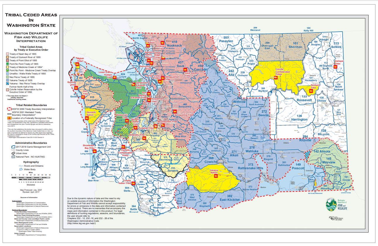
The Native Americans of Puget Sound and the Eastside have enriched this region and the world with the many gifts of their culture. Some of these include:  Art, Dance, Theatre, Science, Philosophy, Life Skills, Technology, Psychology, Education, History, Genealogy, Nomenclature, and Stories. Written, oral and tangible elements remind us of the presence of these people as we explore their heritage and learn from them.

Rivers, mountains, sloughs, lakes, cities, towns and marine vessels with Indian names  are constant reminders of the impact these people have had, and still have, on this region. The Duwamish and The Snoqualmie are two Seattle fireboats that have Indian names.  The former was built in 1890. Together they fought the Grand Trunk Dock fire that erupted in Seattle on July 30,1914.  Snoqualmie Pass carries the name of the  Snoqualmie people living in that area. Places such as Issaquah, Sammamish, Leschi,  Nisqually, Snohomish, Tahoma, Stillaquamish, Seattle (Sealth), Skagit are all Native American names used today. These names are woven into the tangible and geographic fabric of the Lake Washington and Puget Sound regions.

Names, stories and artworks are gifts that spring from the beliefs, creativity and richness of local Native American culture. Women basket makers were respected for their skill and artistry in creating utilitarian and beautiful baskets usually woven from plant materials. Some baskets were so tightly woven they could hold liquids. Others were made with twigs spaced apart. These clam baskets allowed the water, sand and mud to drain out. Loops along the upper rim held ferns in place to cover food items in the basket. Harvesting, preparing and working with the plant materials is a skill in itself. Creating the basket and its design is another skill. It takes many years before a basket maker becomes an accomplished artisan. Some women became weavers making traditional Salish ceremonial blankets with white background and occasional dark lines. The blankets were usually made from mountain goat hair and that of a small dog. The breed of the dog is yet to be determined, but it is thought to have resembled a small white poodle or pomeranian whose hair could be sheared. These women held a respected position in the villages. 

2004.013.004 - Naming Blanket, made by Fran and Bill James.

2004.013.004 - Naming Blanket, made by Fran and Bill James.

2004.013.005 - Cedar bark woven with bear grass, made by Yvonne Peterson.

2004.013.005 - Cedar bark woven with bear grass, made by Yvonne Peterson.

Dudley Carter's carving at Marymoor

Dudley Carter's carving at Marymoor

Much of the fiber artwork such as baskets and weaving took place in the longhouses, as did the story telling. Local Indians lived in houses made from split cedar wood planks. The roofs were slanted from front to back in order to shed the rain. Large roof beams held up by decorated house posts were carved by skilled craftsmen. These posts, like the ones presently found at Beaver Lake Park in Sammamish, often depict stories, characters and songs. Song Dots on the posts represent songs while the figures represent stories. Stories are teachings that tell about the origin of things in the world, human characteristics and natural features. A Snoqualmie story titled, “Snoqualm, Moon The Transformer”, tells about the origins of the area between North Bend and Snoqualmie. Snoqualmie (English spelling) means “The Transformer’s People”.  A decorative pole depicting the story was carved by non-Native American Dudley Carter. The artwork can be found at Marymoor Park in Redmond. The story tells about how two Indian sisters fell asleep in the Snoqualmie prairie after digging fern roots. During the night the younger sister looked up at the stars above and wished that she could marry the white star and her sister marry the red star. Her wish came true when the star men picked up the girls and took them to the sky world. The elder sister became pregnant and delivered a baby boy who later was named, Moon the Transformer. By this naming time he had become an adult and the sisters had returned to their home by making a rope and sliding down it. Rat later chewed on the rope which fell to Earth from the sky world. The rope turned into a rock presently known as, Quarry Rock. As an adult, Moon transforms the Snoqualmie area by creating the natural features and peoples. He then goes into the sky to shed light by night while his younger brother, Sun, sheds light by day. The original version of the story is long, rich in detail and can be found at the University of Washington libraries.

Salmon Woman sculpture located at Highland Community Center, Bellevue

Salmon Woman sculpture located at Highland Community Center, Bellevue

Native American art works are located in a myriad of places throughout the Eastside and Washington State. One Eastside location is at the front of the Highland Community Center on Bel-Red Road, Bellevue. The sculpture, created by Tom Jay and installed in 1991, is titled “Salmon Woman”. Some art works are local while others travel farther afield. A statue of Nisqually tribal leader and treaty rights activist, Billy Frank Jr. who died in 2014 at the age of 83, is being installed in Statuary Hall in the United States Capitol. A totem pole created by Lummi carvers is being taken to President Biden. It began its cross-country journey from Washington State on May 25, 2021 with an expected return date of June 14, 2021. The sacred journey with many stops along the route is a way of calling attention to the protection of Indigenous sacred places. The pole will be featured in the fall of 2021 at the Smithsonian National Museum of the American Indian --- a fine tribute to the original peoples of this land through the power of their art, stories and culture.


Resources

Books:

Puget Sound Maritime Historical Society, Images of America: Maritime Seattle, 2002.

Bohan, Heidi, The People of Cascadia: Pacific Northwest Native American History, 2009.

Pamphlet:

Beaver Lake Park: Totem Pole and House Post Dedication, 12/5/1992.

Newspaper Articles:

Snoqualmie Valley Reporter, “Moon The Transformer” by Kenneth G. “Greg” Watson.

The Seattle Times, “A Sacred Journey” by Linda V. Mapes 4/12/2021.

The Seattle Times, “His voice will speak”: Billy Frank Jr. statue to represent state at U.S. Capitol    4/15/2021.

Native Americans of Puget Sound and the Eastside Part 2

European Contact: White Settlers

BY Barb williams, EASTSIDE HERITAGE CENTER VOLUNTEER

Map, Tribal Ceded Areas in Washington State, Washington State Department of Fish and Wildlife.

Map, Tribal Ceded Areas in Washington State, Washington State Department of Fish and Wildlife.

In the early days, 6,000 or more years before White settlers came to Puget Sound and the Eastside, the Duwamish and Snoqualmie peoples were the dominant indigenous groups in the area. Despite intermittent raids and skirmishes between groups, the people were primarily peaceful. Their lives were supported by the bounty of the natural resources in the area, both plant and animal. The salmon returned each year to the creeks, rivers, lakes and saltwater bays. The villages were located close to these waterways which enabled easy transportation and acquisition of food. Duwamish longhouses were mostly located at the only waterway outlet from Lake Washington (originally known as Duwamish Lake) to Puget Sound. In 1849, Isaac Ebey came to the lake. He called it Lake Geneva. Several years later patriotic United States settlers moved into the area and changed the name to Lake Washington. Thus began White settlement that brought permanent changes to the region and to the lives of the indigenous peoples. White/Indian relationships were basically friendly prior to the signing of the Point Elliott Treaty in 1855.  However, following the signing, some Indian peoples became hostile once they realized their lands and traditional harvesting rights were being impacted by the White settlers. The Hudson’s Bay Company had come to trade with the Indians, but the United States had come to settle and take over their lands. 

Many indigenous groups spoke their own language, but all in this area belonged to the Salishan family whose parent language was known as, Chinook.  A new language was developed after 1792 when Captain Vancouver visited the Puget Sound area and the Hudson’s Bay Company began trading goods with the Indian people. The new language called Chinook jargon was created to facilitate communication between Indian peoples, fur traders, explorers and early settlers. Washington was the center of Chinook jargon that dated from about 1810. It consisted of an estimated 200 words of Chinook Indian language, mixed with Nootka, English, French and other languages. Some Native Americans used the new language and learned English, but others did not.

One of those who did not was Chief Sealth who had become the primary chief of the Puget Sound region. He never learned English or Chinook jargon because he felt it was beneath the dignity of the chief (himself) of his people. But he was always a friend of the White people. He wore a Hudson’s Bay blanket and was the first signer of the Point Elliott Treaty. He became a Catholic and held daily prayer meetings for his people. He was born in 1790 on Blake Island, a tribal camping ground, and passed away June 7, 1866. His daughter, Kakisimia, known as Princess Angeline, learned to speak English. It is said that she paddled her canoe through a blinding snowstorm to warn the garrison at Seattle of the impending Indian attack during the Battle of Seattle on January 6, 1856.

Unfulfilled Treaty promises granted to the Indian people in exchange for their lands stirred their discontent which resulted in the attack on Seattle. Hundreds of Indian warriors came to fight for their rights. However, after a day of fighting in which the U.S. Navy warship, the Decatur, fired its cannons killing many warriors, they retreated to the Eastside and over the Cascade Mountains from whence they had come. Leschi, the war-chief of the Nisquallies rallied his warriors for the attack on Seattle at a site on the western shores of Lake Washington. The site remained an Indian village called Fleaburg that was inhabited until the 1880s. Presently a Seattle suburb and a park called Leschi are located at the site. Other Indian warriors had gathered for the attack on Seattle at a large village site located on the eastern shores of Lake Washington near present-day Factoria.

OR/L 79.79.469 - Marie Louie or her sister Julia, Taken on the Lake Sammamish Road near Inglewood in 1914.

OR/L 79.79.469 - Marie Louie or her sister Julia, Taken on the Lake Sammamish Road near Inglewood in 1914.

As mentioned earlier, the battle was the result of discontent as the Indian people began to experience the true meaning of their leaders signing the Point Elliott Treaty at Mukilteo on January 22, 1855. The Treaty document, hastily presented to many Native American groups by Governor Isaac Stevens, was presented in a language that many Indian leaders, as signers, did not necessarily understand. It gave Indian lands to the United States in return for compensation and rights. However, it was not ratified for four years and the promises had not been fulfilled. Tensions began to build during the summer of 1855. This resulted in the Treaty Wars of 1855-1856. By then the population of lake people Indians had been reduced by 80%, a result of the small pox epidemic in the 1830s. Many of the people had been moved to reservations. Those who remained in their homes, discovered that they were not allowed to hunt and fish at their traditional grounds --- a “right” they thought had been promised to them in exchange for their lands. Some of those who stayed in place were Snoqualmie people. 

Marie Louie, a Snoqualmie Indian princess whose Indian name was Gotshoblo, was one who stayed. She was born at Tolt (Carnation) in 1798 and died in 1917. She was a friend of the White settlers and often helped deliver their babies, such as the Pickerings baby. Bessie Wilson Crane’s birth was facilitated by Marie Louie.  Her family lived in Issaquah. Bessie’s daughter’s birth was assisted by Marie Louie.  Bessie remembered how much “Aunt Louie” loved children and would often sing to them. As a medicinal herbalist for her people, she enjoyed teaching pioneer children about the ways of the woods and streams. She was a well-known figure as she paddled her big canoe from Issaquah on Lake Sammamish, through the Sammamish Slough, south on Lake Washington to the Black River that connected to the Duwamish River, and into Elliott Bay to Seattle. There she sold the rag rugs she made from settlers’ worn out clothing. Her round trip took her almost a month to complete. She was approaching Seattle on June 7, 1889 when 32 blocks of Seattle’s business and commercial district burned. Her friend, Arthur Denny, warned her about the fire and saved her from coming ashore. Always helpful to White settlers, she walked several times in her bare feet to Yakima and back bringing with her new hops plants for the hops farmers on the Eastside.  

Following the signing of the Point Elliott Treaty, many Indian people needed a way to make a living. Some worked in laundry and lumber while providing a valuable workforce that contributed mightily to the successful growth of Seattle. Some came from miles away to work as paid help for the hops farmers in Issaquah, Fall City, and Auburn. These were good jobs for the men, women, and children. Others helped White settlers transport their provisions in their big canoes. It is said that the canoes could carry as much as two tons of goods. Indian guides showed White settlers water and land passageways and how to survive in the new land. In his journal, Reverend R. W. Summers writes that on July 17, 1871 Indian guides took him by canoe to their sacred place, Snoqualmie Falls. The Perrigo family set up a trading post in Redmond. They traded with members of four different Indian tribes and used Indian ponies to expand their business to farms between Redmond, Tolt and Novelty Hill.

L 88.029.003.7 - Snoqualmie Valley Native American hop farmers and workers, 1890.

L 88.029.003.7 - Snoqualmie Valley Native American hop farmers and workers, 1890.

Some Indians were both hostile and friendly to White people. Chief Patkanim of the Snoqualmie people was one of them. In 1849 he and his warriors attacked the settlers at Fort Nisqually, but during the Indian Wars of 1855-1856, he gathered eighty warriors of his tribe to help the White people. However, the Castro family of Issaquah was not so fortunate when they were murdered by Indian people as revenge for Indians that had been killed by White people. The years following the signing of the Point Elliott Treaty in 1855 resulted in a mixed relationship for both the Indian people and White settlers living in the Puget Sound and Eastside regions.

As more and more White settlers came to the region bringing with them their values and need for wood, coal, farming and industry, the area was greatly changed. In 1916 the Government Locks were built to connect the northern end of Lake Washington to Puget Sound. Because Lake Washington is higher in elevation than Puget Sound, the water levels throughout the Eastside dropped  9 to 12 feet. This greatly impacted the Indian peoples. The Wapato plant they depended on for food disappeared and the Black River all but dried up causing the large village on its banks to be abandoned and the southern water link to Elliott Bay to be blocked. Instead, the Cedar River began to flow into Lake Washington and the lake drained north past the University of Washington through the locks to Puget Sound. By this time many Native Americans were living on reservation lands. Some groups had been recognized by the United States government which entitled them to government programs and aid. Others had set up their own businesses, graduated from schools and universities and had become part of the new way of life.

However, there is one group, the Duwamish, that is still awaiting United States Government Recognition. At present there is a movement towards gaining Recognition and a petition (#StandWithTheDuwamish) circulating asking for support towards that end. The Duwamish people have built a beautiful community center near the mouth of the Duwamish River on the western side. They offer public programs, artworks and a wonderful place in which to connect with their culture.

Let us remember the Indian peoples who first inhabited these lands. They deserve our respect and gratitude for the gifts they have given to this region we all call “home”.  


For more information about the Indigenous communities of Washington state, please visit the American Library Association at the link below.


Resources

Books:

Fish, Edwards R. Past at Present at Issaquah Washington, copyright 1967.

Craine, Bessie Wilson Squak Valley, 1983.

McConaghy, Lorraine New Land, North of the Columbia, copyright 2011.

Thrush, Coll Native Seattle, University of Washington Press, 2007.

A Publication of the Seattle Times A Hidden Past articles 12/1997 to 1/2000.

Annotated bibliography of the following books: 

Dupar, Robert W. Meydenbauer History, 1989.

Karolevitz, Robert F. Kemper Freeman, Sr. and the Bellevue Story, 1984.

Eastside Heritage Center collections:

C.T. Conover, three articles that begin with the title, Just Cogitating: Puget Sound Indian Customs, Notes About Puget Sound Indians, Chief Seattle Had Dignified Appearance, Puget Sound Indian Tribes.

David Buerge article, Indian Lake Washington, The Weekly, 8/1 - 8/7 1984.

Frank Lynch article, Seattle is Named after a Slaveholder, Seattle Scene.

Pat Sandbo Salish Traditional Life Skills, based on a presentation by Steve & Dorothy Phillip.

Paul Shukovsky article, Duwamish Tribe Fights for Recognition, Seattle P-I 9/5/2008.

Nancy Way article, Perrigos start first inn and trading post near Redmond, Redmond Sammamish Valley News, August 16, 1995.

Charles W. Smith book chapter, “An Old Quaker Magazine”.

Photograph of Marie Louie inscription

Newspaper articles:

The Seattle Times June 7, 2021, Opinion, Give Duwamish Tribe Overdue Recognition

The Seattle Times June 13, 2021, Paid Advertising, Who Are the Duwamish?

Website:

Treaty history and interpretation. Washington Department of Fish & Wildlife. (n.d.). https://wdfw.wa.gov/hunting/management/tribal/history.

Native Americans of Puget Sound and the Eastside Part One

Early Years: Pre-European Contact

BY Barb williams, EASTSIDE HERITAGE CENTER VOLUNTEER

Native American stories often begin with the words “In the Early Days Long Ago when the world was very young-----”. This story about the indigenous peoples that inhabited the shores of Lake Washington and the Eastside begins thousands of years ago before white settlers came to the region. The story is grounded in years of research and oral histories.

The area was beautiful with an abundance of natural resources. Freshwater flowed into Lake Washington from the many creeks along its shores. Water was plentiful as was the flora and fauna found along its banks and hills. The Black River at the south end of the lake was the only outlet to the saltwater. It connected to the Duwamish River that emptied into Elliott Bay. These rivers provided the passageway along which the adult salmon returned annually to the lake to spawn and for the young salmon to begin their journey downstream to the saltwater. This critical feature provided the people with a food source upon which they depended. For this reason, they often built their villages at the mouths of creeks where the salmon spawned. The landlocked Kokanee salmon that inhabited the lake were prized by other groups who travelled from the north to fish and return home with the tender meat. Arthur Ballard, a resident of Auburn, Washington, called these indigenous people, The Lake People or hah-chu-AHBSH. HAH -chu means “lake” and ahbsh means “people of”. Most of these people belonged to the Duwamish or Snoqualmie; sub groups of the Coast Salish. They spoke Chinook jargon, but also their own local dialect. Many of the place-names in use today originated with the names of these peoples.

Lake Washington before water was lowered, 1915. (L96.025.020)

Lake Washington before water was lowered, 1915. (L96.025.020)

Archaeological sites on the Eastside have revealed much about these early Native Americans. One of the oldest sites is at Tokul Creek flats which is at the confluence of Tokul Creek and the Snoqualmie River, below the falls. According to archaeologist, Astrid Blukis Onat, who studied the site in 1967, the area was used for over 2,500 years. Another important site is the one at Marymoor Park situated along the Sammamish Slough in Redmond. More than a thousand artifacts were found revealing a hunting civilization: arrowheads, blades, and awls used to punch holes in hides were among the items discovered there. Along the Black River two villages were found. The first was inhabited from about 1790 to 1825 and the second between 1850 to 1856. There have been eighteen sites studied around the shores of Lake Washington. Each village site revealed dwelling(s), artifacts and had its own burial ground. The tu-oh-beh-BAHBSH site near Thorton Creek revealed one house and access to the large cranberry bog where Northgate is presently located. The TAHB-tah-byook site is located at the mouth of Juanita Creek with possibly seven houses. They enjoyed feasting on what was considered some of the best Wapato in the Puget Sound area. The Wapato, often referred to as the Indian Potato, was a staple food plant for the native Americans. The root was roasted like a potato and was a source of starch. The SAH-tsa-kah-LUBSH (head of the slough people) had three houses on the Mercer Slough and close to present-day Factoria. It was an important site being the terminus at the lake for the trail that lead to Lake Sammamish, onward to Snoqualmie prairies where trading took place, and to areas east of the Cascade Mountains. It was along this trail that one hundred Yakima and Wenatchee Indian warriors came in 1855 to fight the Battle of Seattle. The village site and its headman, Che-shi-ahud (Lake John), sheltered the warriors. To the northwest at Meydenbauer Bay, the villagers caught peamouth fish in Meydenbauer Creek. The long marsh that stretched south of the village for three miles was a productive natural resource. Women dug cattail roots for food and used the leaves to make mats often used for house construction when the people left the winter houses for their summer harvesting grounds. The marsh grasses along with twigs and bark provided materials for baskets woven by the women. Some were so tightly woven, they could hold water and were used for cooking. Volcanic rocks were heated in the fire and then placed in the water at intervals to keep the water hot. In this way the food was cooked or boiled. Some foods such as salmon were dried. This was the case at the village site called, shu-bahl-tu-AHBSH (drying house people) located at May Creek where the salmon runs were plentiful. The fish were dried on racks or cured in the smoke houses. 

A popular deer hunting area was a field on Mercer Island where the deer were driven across the water to a location near Beaux Arts. Here they came ashore exhausted from their swim and were killed. The Native Americans hunted on Mercer Island, but never stayed overnight due to a belief that a monster lived at the top of the island and the island sank into the lake at night. This idea may have originated with the changing water levels due to seasonal flooding, landslides and other natural causes. Presently, there are two known upright, underwater forests that slid into the lake: one at the north end of the island and the other at the south end.  

A large western red cedar bark berry-picking basket. (C2-64)

A large western red cedar bark berry-picking basket. (C2-64)

There was much trading among local and outside groups. Trade pathways from Elliott Bay to east of the Cascade mountains developed. Northern peoples came to trade, visit and raid the villages for slaves and goods. Marriages were common between villages and peoples of different groups. During the summer months, there was much celebrating and villagers could be found at their summer harvest sites. When the salmon runs came in the fall, everybody worked. During the winter months, the people returned to their winter homes, processed the summer’s harvest, made items for use and danced and sang in celebration of the ancestors and spirits.

The Lake People, like many indigenous peoples, developed a clever technology to support their daily needs. From basketry, tools, clothing, canoes, house construction, hunting tools and so much more, they relied on the natural resources in their environment. A specialized duck harpoon was created that had two prongs that caught in the feathers of the ducks. When the migrating flocks of waterbirds came to the lake and marsh, the men set fires on clay hearths in their canoes. The flickering of those fires could be seen at night along the shorelines. The fires drew the birds out of the marshes whereupon they were ensnared in large nets made from the twine of stinging nettle plants, or caught with the duck harpoon. 

Much of the local Native American Pre-European Contact history is observed or spoken. Thanks to researchers and contributors, it is being discovered and valued for the wonderful lessons the Lake People of Lake Washington and Puget Sound have to teach us. Over all, life seemed good for the people and resources plentiful during this historic time.  


Resources

Bohan, Heidi. “The People of Cascadia: Pacific Northwest American History” c. 2009

Buerge, David. “Indian Lake Washington”, article in The Weekly, August 1 - August 7, 1984.

Margeson, Doug. “History underfoot: Eastside abounds in ancient Native American camps and villages”, article in Living, Wednesday, September 22, 1993.

Williams, Jacqueline and Goldie Silverman. “Beyond Smoked Salmon”, article.


Part of our Award Winning Eastside Stories Series

A History of Snoqualmie Pass: Tourists, Recreationists, and Environmentalists

Eastside Stories is our way of sharing Eastside history through the many events, people places and interesting bits of information that we collect at the Eastside Heritage Center. We hope you enjoy these stories and share them with friends and famil…

Eastside Stories is our way of sharing Eastside history through the many events, people places and interesting bits of information that we collect at the Eastside Heritage Center. We hope you enjoy these stories and share them with friends and family.

By Angeline Nesbit

The creation of the highway through Snoqualmie Pass has a history of over 6,000 years starting with the first indigenous peoples who traveled it on foot. That history continues to be made as we expand and change the highway to be more efficient, stable, and safe for travelers. Conquering the geographic elements which once were considered too formidable a barrier for people to cross regularly, people now engage in many recreational activities in the surrounding area of the pass.

Opening this space for hikers, hunters, and tourists also has its own history. Preserving the forests and history around the pass is an environmental concern which has attracted several projects and land purchases. Converting spaces that were apart of historical industries and routes through the mountains into places for recreation is the next step in human interest in the Snoqualmie Pass area.

An early project embarked on by the Boy Scouts of America and the Forest Service before the 1980s was to hack away the brush and open part to the wagon road built in 1868. They preserved what was left of some of the early trail for hikers to enjoy. This 1-mile stretch was the original foot and horse trail of Native Americans which was widened to a wagon road. This trail can be accessed near Denny Creek Campground.

Encouraging more hikers, in September 1994 the Snoqualmie tunnel built by Milwaukee Road railways 80 years before, opened to hikers and mountain bikers. The Milwaukee Road railways were some of the first electrified trains which traveled westward through their own protected tunnels. The tunnel was built with the help of 2,500 men whose labor, along with blasting materials, broke through 12,000 feet of solid rock. Two teams met in the middle to complete the large project. Massive wooden doors protect the entrance to the tunnel which railroad employees stood by to open for approaching trains. This kept icicles from forming in the very cold and damp tunnel. A cold wind emits from the tunnel strong enough to rustle clothing. The Snoqualmie Tunnel is the longest hiking tunnel in the US at 2.3 miles long. It runs over the county line between King and Kittitas counties, creating a link in the Iron Horse Trail to the west and Hyak trail to the east.

A few years later, in a huge land deal the company known as Weyerhaeuser sold over 100,000 acres of forested land they used as a tree farm to a trust which guaranteed it’ preservation permanently. This was a $185 million-dollar deal with the Evergreen Forest Trust, who has long been attempting the protection of the land. “Evergreen Forest” at Snoqualmie was acquired in 2002. At the time it was already being used by recreationalists with a fee to the Weyerhaeuser company. This site is home to old growth trees and rich wildlife making it an ideal recreation area.

Surrounded by national parks, including Mount Baker National Forest, Mount Rainier National Park, and Okanagan-Wenatchee National Forest the land around Snoqualmie Pass is beautifully preserved. Despite the many people who speed through each year the Cascades remain a haven of natural beauty which inspires people to slow down and enjoy the view. Next time you travel the pass leave time to stop and enjoy the natural world which surrounds this human made structure.

Photo (above): On a motor trip to Snoqualmie Summit this photograph shows group of people standing in front of cars, in front of long buildings.

Photo (above): On a motor trip to Snoqualmie Summit this photograph shows group of people standing in front of cars, in front of long buildings.


Resources

Eastside Heritage Center Archives

“Snoqualmie Pass: From Indian Trail to Interstate” by Yvonne Prater

A History of Snoqualmie: Transportation Across the Cascades

Eastside Stories is our way of sharing Eastside history through the many events, people places and interesting bits of information that we collect at the Eastside Heritage Center. We hope you enjoy these stories and share them with friends and famil…

Eastside Stories is our way of sharing Eastside history through the many events, people places and interesting bits of information that we collect at the Eastside Heritage Center. We hope you enjoy these stories and share them with friends and family.

By Angeline Nesbit

The Snoqualmie Pass road project was first conceptualized in the 1840s, but construction of the road stopped and started with the political and economic concerns of the region and country. The road didn’t reach a point where it resembled a real highway until about 1895. Constructed with Cedar planks to help keep the road even and drivable, cars began to travel the route although often having to adapt to weather changes quickly.

Automobiles are just the most recent form of travel through the Cascades though. Native Americans walked across the mountains for thousands of years before a large road was cut out. Using a slightly different route than Snoqualmie Pass follows today, indigenous peoples were able to maintain trade routes between east and west. With the introduction of the horse these routes were even more readily traveled. Today one mile of the original route, which also laid groundwork for European colonizer’s eventual road, is preserved near Denny’s creek.

Early European and American settlers came in wagons and on horseback as well across the route, but they remained partial to travel by water until the road began to be more established in the late 1800s. Still freight wagons bringing goods out west used the road readily. In 1909 the Alaska-Yukon Exposition created a reason to improve the road as people flocked to attend the event.

Photo (above): Men with car on Snoqualmie Pass highway, probably near North Bend, taken in 1916.

Photo (above): Men with car on Snoqualmie Pass highway, probably near North Bend, taken in 1916.

This along with automobiles and tourists are sometimes credited with the final push to create a truly viable pass at Snoqualmie. US route 10, Sunset highway opened in 1915, a greatly improved road to allow easy travel for motorists. Still, the road was often perilous, and motorists were sometimes inclined to park their cars on railway flatbeds and take the train through the pass in inclement weather.

The Milwaukee Road was one of these railways. Building railroads and tunnels through the pass they transported goods, people, and other items. Milwaukee Road used some of the first electrified trains which traveled westward through their own protected tunnels to speed travel. Their train, The Olympian, was the first passenger train to go through the Snoqualmie tunnel in January 1915.

Dramatic changes in transportation are a part of what has shaped the Eastside. Without roads like the Snoqualmie Pass highway (known as I-90) our region of eastern King County would find travel to the east extremely difficult. Developing the road to allow for the safe travel of cars and trucks made the large community we live in today possible.

Resources

Eastside Heritage Center Archives

A History of Snoqualmie Part 3: Conceiving the First Roads Through the Cascades

Eastside Stories is our way of sharing Eastside history through the many events, people places and interesting bits of information that we collect at the Eastside Heritage Center. We hope you enjoy these stories and share them with friends and …

Eastside Stories is our way of sharing Eastside history through the many events, people places and interesting bits of information that we collect at the Eastside Heritage Center. We hope you enjoy these stories and share them with friends and family.

Eastside Stories

The pressures which created the first road through Snoqualmie Pass hinged on the increase in population seen as the Seattle area’s population grew. Even as the project was beginning though, some maintained that it was too dangerous to travel by land. Explorers, fur traders and the eventual colonial settlers that arrived on the Eastside avoided the Cascades for a long time because of the danger posed by terrain and weather. Early arrivals traveled by water and through Oregon to avoid the formidable Cascade Range. The first road was proposed to bring more settlers quickly through the mountains.

The first route, Naches Pass to the south of Snoqualmie Pass, was one of the routes shown to European explores by Native Americans. White settlers took advantage of this indigenous knowledge as they carved out the first wagon road there. One of the first parties to cross through Naches Pass is said to have lowered its wagons by leather ropes down a 1,000-foot drop above Pyramid Creek. This party, known as the James Longmire and James Biles party, comprised over 100 people and came through the mountains short of food and bedraggled. In order to limit the hardship and endangerment of people traveling to the region, territorial leaders made building a better road a priority.

In 1853 Territorial Governor Issac Stevens was appointed by President Pierce to survey potential transcontinental railroad routes between the Great Lakes and Puget Sound. Stevens sent Captain George McClellan to find a route through the Cascades. McClellan traveled the native people’s horse route over Yakima Pass west of Lake Keechelus and just south of the pass we know today as Snoqualmie Pass. (It took a while for the newcomers to the region to figure out that the native people used two routes over the mountains. The one across what we know as Snoqualmie Pass was a foot path, the route over Yakima Pass a horse trail.) He reported that too much snow and geographic barriers made the route unusable. Not taking no for an answer, Stevens sent Lieutenant Abiel Tinkham two years later to survey a route. Tinkham set out in September with several native guides and struggled through deep snow over Yakima Pass. Not until 1856 did a party under the command of Major J. H. H. VanBokkelen successfully travel east through Snoqualmie Pass as part of an expedition to scout possible locations for forts during the so-called Indian Wars (1855-56). [article continues below]

Photo (above) :Snoqualmie Pass Wagon Road photographed in 1910.

Photo (above) :Snoqualmie Pass Wagon Road photographed in 1910.

The conflicts between colonizing groups who had settled in the Seattle area and the indigenous population had originally caused these settlers to stick close to their towns and take routes over water rather than land. It wasn’t until these conflicts escalated to include the US military in the Puget Sound War of 1855-56 that the land to the east seemed to open for European settlers.

The Puget Sound War encouraged the US federal government to look for funding to create a military highway as defense of the region proved difficult. Although a bill was passed into Congress for funding not much came of it. The Civil War interrupted Federal attempts to build a road as the focus of the nation moved elsewhere.

New laws in the 1850s and 60s encouraged people to migrate to the Puget Sound region and may have inspired the cutting of roads through the Cascades. The original wagon road was built over Snoqualmie Pass in 1868, proving a path less formidable than Naches Pass. It seems the geography of the Cascade Mountains can both help and hinder roads through the range. High peaks and sometimes uneven terrain are offset by flat bottom valleys created by Ice Age glaciers which made making a road through Snoqualmie pass much easier than it could have been.

Resources

Eastside Heritage Center Archives

“Snoqualmie Pass: From Indian Trail to Interstate” by Yvonne Prater

A History of Snoqualmie Pass Part 1: Crossing the Northern Cascades Before Roads

Eastside Stories is our way of sharing Eastside history through the many events, people places and interesting bits of information that we collect at the Eastside Heritage Center. We hope you enjoy these stories and share them with friends and …

Eastside Stories is our way of sharing Eastside history through the many events, people places and interesting bits of information that we collect at the Eastside Heritage Center. We hope you enjoy these stories and share them with friends and family.

Eastside Stories

To the east of Lake Washington lay the Cascade mountains, a range of peaks which reaches over 700 miles from Northern California to Canada. This stretch of rugged topography posed a formidable barrier to those traveling on foot to the Pacific before the creation of a road. Both creating a barrier and a life-source, water flows down from multiple rivers and lakes in the Cascades, increasing as snow melts in the summer. This water flows all the way to Lake Washington via winding rivers, creeks, and other bodies of water throughout King County.

Water is the reason the geography that we know today exists. Glaciers and the water flows associated with them have helped to form much of Washington State’s geography. In the Pleistocene (about 20,000 years ago), the Cordilleran Ice Sheet reached its’ farthest extent, covering much of Canada and the United States. 14,000 to 11,000 years ago it began to recede. As it moved north past the Canadian border, the Cordilleran Ice Sheet created many mountain valleys including the route we call Snoqualmie Pass today.

Human activity is recorded along this route as early as 6,000 years ago and indigenous groups lived in the area long before this, during the time of the glaciers. Native Americans used the route on foot for thousands of years and taught it to European explorers and trappers who came to Washington State in the 18th and 19th century. Indigenous groups from both sides of the Cascade Range traveled back and forth to trade game, plants, and other goods, a practice that continued for some tribes until the 1940s or later when military action in the middle of the state interrupted traditional hunting and foraging as well as routes of travel. 

The arrival of the horse in the 1740s encouraged this kind of trade, allowing groups like the Snoqualmie who occupied the Cascades to trade with those from the interior plains. Past encampments of indigenous groups have been found by archaeologists near food sources including berry patches and rivers where fish were readily available. By the 1840s and 50s, when a formal road was being discussed, Native Americans had already been influenced by European colonizers and goods which transformed styles of dress and economic patterns. Early Europeans also introduced smallpox, reducing the population greatly during early excursions to the region.

In the first half of the 1800s several European visitors to the region recorded being guided by indigenous populations through Snoqualmie Pass and on other routes. Although today hundreds of people pass through the Cascades in an hour or less, until the project to build a road was formally undertaken by state and federal government only about a dozen people passed through each year. Although many thought it safest to travel by water, the effects of war and Manifest Destiny on the region led to the desire for a quicker route for people to travel from east to west.

Resources

Eastside Heritage Center Archives

http://glaciers.us/jhbretz.html

“Snoqualmie Pass: From Indian Trail to Interstate” by Yvonne Prater

Eastside Stories: Indigenous Stories in a Land of Change

Eastside Stories is our way of sharing Eastside history through the many events, people places and interesting bits of information that we collect at the Eastside Heritage Center. We hope you enjoy these stories and share them with friends and famil…

Eastside Stories is our way of sharing Eastside history through the many events, people places and interesting bits of information that we collect at the Eastside Heritage Center. We hope you enjoy these stories and share them with friends and family.

In a place where violent acts of nature are common in the form of landslides and wildfires, and the threat of earthquakes and volcanoes are ever present, Native American stories show how these kinds of events have unending possibilities for humanity. Many Native American stories from the Eastside and surrounding areas tell of a powerful being who came and transformed the world from what it was into what it is today. Groups like the Snoqualmie and Muckleshoot peoples believe in a deity who aided people and made great changes to the earth and animals. This transformative being is known by many names including The Changer, Moon the Transformer, Xode, Snoqualmie, and Dukʷibeł. The changes and transformations brought on by these creators made the region of western Washington inhabitable for human beings and allowed crafts such as woodworking to begin.

For the Snoqualmie, Dukʷibeł (Moon the Transformer) is the son of a human girl and a star. As a baby, he was stolen away and gained magical powers which allowed him to come back and transform the world. Lake Washington and all the cities and towns around it make up the ancestral land of the Muckleshoot, Snoqualmie, Duwamish, Coast Salish, and other indigenous groups who had and maintain a deep knowledge of the environment around them through sharing skills, stories, and stories.

Snoqualmie Valley Hop Farmers and Workers, c. 1890. L88.029.003.7

Snoqualmie Valley Hop Farmers and Workers, c. 1890. L88.029.003.7

“This is the land of the Changer, the Star Child who descended from the heavens to the fertile earth and, as Moon, married a daughter of the Salmon people, ensuring his human kin happiness and plenty if they would respect the family of his bride.” The Changer pops up in other stories but his largest work was in the shaping of the land around us. It is said that he announced his plan to make the earth into a place for human beings before coming to Western Washington to do his work of creating the world as we know it today. Some animals were angered by this and deer are said to have prepared bow and arrow to fight The Changer. When The Changer came he took the arrows and stuck them into the deer’s head, making them docile and turning them into prey. Actions like this turned the earth into a place where human beings could live.

In the many stories about this transformative deity, the great changes he creates are almost always beneficial to humans as a whole or as individuals. The tribes of our area reveal their great understanding of the changes that came before humanity arrived to the geological landscape. Recently, indigenous stories have begun to gain the respect they deserve as sources of knowledge and a form of information sharing. In fact, the area of Geomythology has been gaining ground in the scientific field as stories from indigenous people around the globe prove to be records of previous geological changes. For example, the Duwamish tell of a large red sandstone boulder called ‘yahos’ that animal spirits are said to live in. These boulders indicate fault lines and areas of previous seismic violence, having been pushed up by the shifting of the earth. Fear of these rocks would have protected people from settling in areas that were prone to dangerous geological occurrences.

The story of The Changer and Moon the Transformer also teach people today about the beautiful land in Washington, west of the Rockies. By making change into a positive force and honoring the one who brings those changes, Indigenous people of Western Washington demonstrate their knowledge that even catastrophic environmental events can bring renewal and replenishment to the earth.


Sources

Beurge, David M. "Native Americans of the Pacific Northwest: An Introduction." American Indians of the Pacific Northwest Collection. Accessed August 06, 2019. https://content.lib.washington.edu/aipnw/buerge1.html

De Los Angeles, Steve. "Story of the Moon." Story of the Moon | Snoqualmie Tribe. 2012. Accessed August 06, 2019. https://www.snoqualmietribe.us/moon

Krajick, Kevin. "Tracking Myth to Geological Reality: Once Dismissed, Myths Are Winning New Attention from Geologists Who Find That They May Encode Valuable Data about Earthquakes, Volcanoes, Tsunamis, and Other Stirrings of the Earth.(News Focus)." Science310, no. 5749 (2005): 762-764.

Matthes, Whitney, Frey, Rodney, Putsche, Laura, and Tripepi, Robert. The Relationship between Plants and People: An Ethnobotanical Study in Partnership with the Muckleshoot Tribe , 2016, ProQuest Dissertations and Theses.

Watson, Kenneth Greg. "Native Americans of Puget Sound -- A Brief History of the First People and Their Cultures." Native Americans of Puget Sound -- A Brief History of the First People and Their Cultures. June 29, 1999. Accessed August 06, 2019. https://www.historylink.org/File/1506