Article by Kent Sullivan, Steve Williams, and John Tun
Eastside Stories is our way of sharing Eastside history through the many events, people places and interesting bits of information that we collect at the Eastside Heritage Center. We hope you enjoy these stories and share them with friends and family.
Newcastle sprung into existence in the years after Federal land surveyors discovered coal just east of Lake Washington in 1862. Seattle, a village of barely 1000 people in 1870, did not generate much demand for coal, but San Francisco, a city 150 times larger, was in great need of it for industrial and residential use, yet its local source (Mt. Diablo) was nearly exhausted. Seattle also greatly desired a “cash crop” to help provide much-needed capital. The timber and lumber businesses, although thriving on the Olympic Peninsula by 1870, were slow to develop in the Seattle area.
Creating a mining operation from scratch, to get coal to the surface, was a substantial challenge—but it was only half the battle, because the coal still had to be transported nearly 20 miles to the nearest ocean-going port, Seattle. The lowlands surrounding Seattle circa 1865 were densely-forested, old-growth wilderness, with absolutely no infrastructure (railroads, roads, settlements, etc.). Small quantities of coal were initially transported by canoe across Lake Washington, switching to small, shallow-draft barges guided south on the lake, to the Black and Duwamish Rivers, to Seattle’s waterfront, but clearly, a viable commercial enterprise could not be sustained with these methods.
Doing something different and more practical required capital—a lot of it—and there was precious little available in the village of Seattle. San Francisco, by comparison, was flush with investment dollars, and its investors were definitely motivated to help the city continue to grow and thrive. Thus, the Seattle Coal & Transportation Company (SC&T) was born in 1870.
The SC&T rapidly got an operation going that would have made Rube Goldberg proud, involving transloading coal 11 times in its journey and the first steam locomotive in the Puget Sound region.
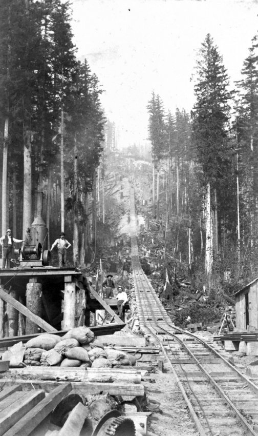
1890's coal mining in the Newcastle Hill and Bellevue area utilized rail systems to move coal.
Amazingly, enough money was made this way that the company shut down for an entire year in mid-1873 to build a more-efficient transportation solution involving three rail segments with three separate locomotives, using a 3’ narrow-gauge system, and two lake segments, using two sets of barges propelled by two steam tugs. This system moved 500 tons of coal per day to the company’s wharf and coal bunker at the foot of Pike St., which was built by the first mayor of Seattle, was the largest structure on the Seattle waterfront in the mid-1870’s, and kept a fleet of 9 clipper ships busy transporting coal to San Francisco.
Even this system was deemed too costly and was replaced by an all-rail route in early 1878. (Please refer to Kurt Armbruster’s excellent book, Pacific Coast: Seattle’s Own Railroad for more information on this operation.) The large numbers of men (and their families) required to operate the complex mine and transportation system propelled Newcastle to become the largest settlement in the area outside of Seattle in the years before 1880.
A dedicated group of members of the Newcastle Historical Society (NHS) has been researching all aspects of the SC&T: the route, equipment, production, people, and more. Last year they uncovered the site of an incline used to lower loaded coal cars to the east shore of Lake Washington. Amazingly, part of the incline site survives today (on private property).
An information-packed presentation on many aspects of the SC&T will be given September 26 at the Bellevue Downtown Library at 7:00 PM, in conjunction with NHS and the Eastside Heritage Society. The public is invited and there is no charge. We hope you’re able to attend and learn more about this fascinating, all-but-forgotten chapter of Newcastle’s early industrial history.
Our Mission To steward Eastside history by actively collecting, preserving, and interpreting documents and artifacts, and by promoting public involvement in and appreciation of this heritage through educational programming and community outreach.
Our Vision To be the leading organization that enhances community identity through the preservation and stewardship of the Eastside’s history.