Eastside Stories

Eastside Stories: Redmond's Great Fire

Eastside Stories is our way of sharing Eastside history through the many events, people places and interesting bits of information that we collect at the Eastside Heritage Center. We hope you enjoy these stories and share them with friends and famil…

Eastside Stories is our way of sharing Eastside history through the many events, people places and interesting bits of information that we collect at the Eastside Heritage Center. We hope you enjoy these stories and share them with friends and family.

Article by: Tom Hitzroth

Frontier towns were typically constructed of wood and could be partially or totally destroyed by a fire that started from a chance spark from many different sources. No community large or small was safe from fire and Redmond was no exception.

On October 26, 1889, William E. Sikes purchased a lot from Luke McRedmond and built the first hotel in Redmond. Sikes called it the Valley Hotel. At this time Redmond was still transitioning from the settlement period in its development and it would be another decade before it took on the character of a town.

Sometime in 1904 or early 1905, Herman S. Reed purchased the property from William Sikes and in 1906 Mary Walther began remodeling the Valley Hotel. The new hotel opened for business as the Hotel Walther by May 1, 1907. On May 12, 1908 Mary Walther purchased the property from Herman S. Reed. On March 13, 1910, a fire started in the hotel. The following is a likely progression of the event based on analysis by a senior fire investigator for the Redmond Fire Department of photographs taken on that day by Winfred Wallace together with the reports from the four major Seattle newspapers.

The investigator verified the chimney was the source of the fire, and explained how the fire spread on the third floor. The first photograph below shows the fire’s progression approximately 15 to 20 minutes after it began. The burn pattern on the east end of the third floor (right in the photograph), and destruction to the window frame suggested that the fire reached an intensity that exploded the third floor window. He also determined, from the way the rafters are exposed the north side of the third floor (farthest away in the photograph) burned faster than the south side.

Once the fire had begun a bucket brigade was formed to save the adjoining property. A call for help was put out to the neighboring communities and Kirkland answered the call. The Kirkland firefighters dragged two pieces of equipment four miles to the scene. However, since Redmond was not on a water system the equipment could not be employed effectively. Unable to suppress the fire there were only a couple of alternatives left. They could let the fire burn, contain it the best they could, and hope it didn’t spread to the rest of the town, or they could try a controlled demolition to bring the fire to an end. It was decided to try a controlled demolition.

The building on the right in the second photograph, though damaged by the fire, was brought down by the controlled demolition. The investigator and I discussed the probable placement of dynamite charges that brought the hotel down. Most likely, because the building was 25 feet north of Cleveland Street, Cleveland Street was 60 feet wide, and based on the density of the surrounding buildings, collapsing the hotel toward Cleveland Street would have been the most viable and sensible option. The fire did not completely burn out until the early morning of March 14.

The destruction of the Hotel Walther in 1910 was a major calamity for Redmond particularly as it jeopardized the survival of the town. Through the skill of those unknown individuals who positioned the dynamite charges that helped contain the fire, the only other buildings lost were a small shed and a barn. The upside was that no customer lost personal belongings in the fire, the hotel furnishings were saved, and no one was injured.

Later in 1910 Mrs. Walther rebuilt the Hotel Walther on the northeast corner of Leary Way and Cleveland Street. In 1912 the property was purchased by Harry Evers and renamed it the Grand Central Hotel.

orl79-79-123.jpg
l87-011-002.jpg

Both photos top and bottom: Walther Hotel burning March 1910. Photographs by Wallace Studio.


Our Mission To steward Eastside history by actively collecting, preserving, and interpreting documents and artifacts, and by promoting public involvement in and appreciation of this heritage through educational programming and community outreach.

Our Vision To be the leading organization that enhances community identity through the preservation and stewardship of the Eastside’s history.

Eastside Stories: Factoria School

Eastside Stories is our way of sharing Eastside history through the many events, people places and interesting bits of information that we collect at the Eastside Heritage Center. We hope you enjoy these stories and share them with friends and famil…

Eastside Stories is our way of sharing Eastside history through the many events, people places and interesting bits of information that we collect at the Eastside Heritage Center. We hope you enjoy these stories and share them with friends and family.

Anyone driving around the Bellevue area these days is familiar with the sight of new school buildings rising to completely replace those built not so very long ago, in the 1950’s and 60’s when the Eastside’s population was soaring. So it’s something of a surprise to discover that here and there remnants of the truly early school buildings live on, hidden in unexpected places. 

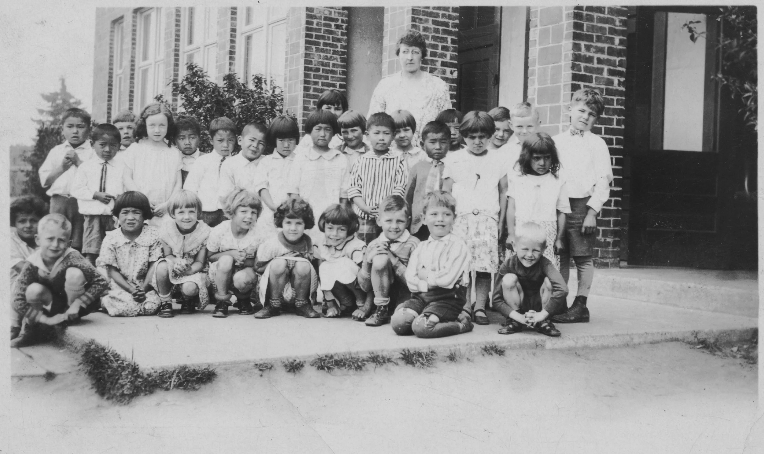
One of those early buildings is the Factoria School, built in 1929 on the side of the hillside overlooking what is now the I-90/ I-405 interchange.  An even earlier schoolhouse, a good-sized frame building, had been built in 1901, creating tiny Factoria School District #134, which never comprised more than one school.  At that time, the east-west route where I-90 now lies was a trail connecting Mercer Landing at Enatai to Robinson Landing on Lake Sammamish People moving north and south went most easily by boat on Lake Washington.  So it is perhaps not surprising that the schools that existed in those days served just their very immediate communities of farmers, loggers, and coal miners.  In 1901 the closest school houses to Factoria were at Wilburton, Newcastle, and near Phantom Lake.

1989.05.04, photo of schoolchildren on steps of school, 1924

1989.05.04, photo of schoolchildren on steps of school, 1924

In 1929 the original school house burned down and was replaced by a brick structure containing four classrooms.  A cement lintel over the front door was incised with the school’s name.  In 1942 District #134, along with five other local districts plus Union S High School, consolidated to become Overlake School District. Wartime brought other changes as well.  Factoria School was closed and turned over to the Army for use as a barracks. It was also one of several  locations on the Eastside that received loads of sand that residents were directed to pick up and keep on hand in case anticipated  bombings caused fires.  The building was returned to the school district after the war and reopened in 1950 as part of newly created Bellevue School District #405.

2005.0280.158, building after sale in 1961

2005.0280.158, building after sale in 1961

In the early 1950’s settlement was still sparse east of what is now I-405:  Somerset, Eastgate and Lake Hills lay in the future.  Factoria’s students, first through fourth graders in four classrooms, came largely from the communities of Norwood Village, Horizon View and Hilltop plus families along Newport Wa, Richards Road, and the lake shore south to Hazelwood. They moved to Enatai School after fourth grade.  One resident who attended the school at that time recalled the year that the entire school went all in for the March of Dimes.  Kids brought in dimes that were stuck onto a long roll of adhesive tape, marked on the back with a different color for each grade. They raised $65.10 and also wrote letters to children at Children’s Orthopedic Hospital in  Seattle who were polio patients. (In those years the fear of contracting polio was very much on children’s minds.)

2013.046.086, Factoria School fire, 1960

2013.046.086, Factoria School fire, 1960

In 1957 a larger school, Woodridge Elementary, opened, and little Factoria School was dedicated to special services personnel but still served as a polling place for two precincts.   In 1960 it burned but wasn’t destroyed.  In 1961 the school district sold the building to Farwest Electronics.  The lintel inscribed “Factoria” was cut away and eventually donated to the Bellevue Historical Society.  For several years it rested beneath trees at Woodridge Elementary.  When that school was torn down and replaced with a new structure in 2008, the lintel was returned to the Eastside Heritage Center, where it now resides, safe and dry but quite unobserved, in the basement of McDowell House.

And what of the old school building?  Against all odds, it would seem, it still lives on.  S.E. 32nd St. dead ends beyond East Shore Unitarian Church in front of a contemporary looking building housing Seattle King County Realtors Association and other offices. Hidden beneath the new façade, the old brick building, now 90 years old, continues to serve a useful purpose to yet another resident on Woodridge Hill.

 By: Margaret - EHC Volunteer


Special thanks to Mary Ellen Piro for previous research into this topic. She left her notes and findings to EHC.


Our Mission To steward Eastside history by actively collecting, preserving, and interpreting documents and artifacts, and by promoting public involvement in and appreciation of this heritage through educational programming and community outreach.

Our Vision To be the leading organization that enhances community identity through the preservation and stewardship of the Eastside’s history.


4Culture.png

Eastside Stories: Remembering What the  1996 Duvall Earthquake Showed Us

Eastside Stories is our way of sharing Eastside history through the many events, people places and interesting bits of information that we collect at the Eastside Heritage Center. We hope you enjoy these stories and share them with friends and famil…

Eastside Stories is our way of sharing Eastside history through the many events, people places and interesting bits of information that we collect at the Eastside Heritage Center. We hope you enjoy these stories and share them with friends and family.

Although the Duvall earthquake that occurred in 1996 is not the largest or most devastating before or since it is an example of a geological event which forced scientists to take a closer look at what we know about the world around us. In 1932, before seismology was a formalized branch of science, an earthquake hit the same spot in Duvall. The earthquake storm that followed in 1932 lasted 6 months with residents harrowed by large quake following small quake without pattern or warning.

The more recent Duvall earthquake struck on Thursday May 2, 1996 and measured 5.3 in magnitude, the largest quake in 30 years. It was felt from Seattle to the Tri-Cities and from Vancouver BC to Portland. The quake was shallow, which would typically ensure a lot of damage but not this time. The only damage recorded by the Seattle Government was two cracked chimneys, a toppled wall, a broken pipe and several cracked foundations. This is nothing compared to the Nisqually earthquake which came 5 years later and injured over 400 people.

The Saturday after the 1996 Duvall earthquake William Steele, who at the time was the Seismology Laboratory Coordinator at the University of Washington, warned that aftershocks were possible for days and even weeks after, just like in 1932. Today William Steel is the Director of Outreach & Information Services and still helps with informing people about how earthquakes operate and what kind of impact they can and do have on the area. The 1996 Duvall quake was followed by 300 substantial aftershocks, just as Steele predicted, that reached up to 3.6 on the magnitude scale.

This image from 1950 showing the view from Hilltop Community was originally used in a Scheffer book. This shows the land that can be so dramatically changed by geological events.

This image from 1950 showing the view from Hilltop Community was originally used in a Scheffer book. This shows the land that can be so dramatically changed by geological events.

At the time of the quake little was known about the fault that caused it. In fact, the location of the epicenter was directly between what was believed to be two separate fault lines, the East Whidbey Island Fault and the Rattlesnake Mountain Fault. The earthquake made scientists aware of a new potential danger beneath the surface. The quake showed that the fault which caused it ran north to south. This is counter to most other fault lines in the area, that run east to west.

The earthquake kicked off new inquiries into the fault lines running under Duvall. Within 3 days scientists were out trying to determine which fault caused the quake, employing all the necessary equipment including geological maps, computer-generated relief picture, and 3-D stereograms, scientists debated what the real pattern of fault lines was on the Eastside. Demonstrating how, even an earthquake that has little impact on the people living on the surface, can cause changes in our understanding of the world.

At the time, these two faults were believed to end with a large distance between the two. The Whidbey Island Fault ending under Everett and the Rattlesnake Mountain Fault ending as far south as Northbend. This earthquake launched a debate with some claiming the two faults may even be connected. The connection between the two fault lines is still up for debate, but, because the epicenter of the quake occurred directly between the Rattlesnake Mountain Fault and the Whidbey Island Fault it was determined that at least the East Whidbey Island Fault must extend further than originally believed. This information makes us safer and more prepared. We have the geological event that occurred just two decades ago to thank for making scientists aware of this geological fault.

Either way, the Eastside remains much more geologically active than the Seattle Area making our need to be prepared for this kind of disaster vital. Although there is an awareness of the danger that this beautiful landscape conceals beneath its surface it is still unlikely that earthquakes will be predictable any time soon. That is why the Washington State enacts policies to help prepare for these kinds of disasters

Historic aerial photograph of the northern end of Lake Washington in King County this shows how in spite of an awareness of the seismic activity in the area, people continued to settle in King County even after the first recorded earthquake in the e…

Historic aerial photograph of the northern end of Lake Washington in King County this shows how in spite of an awareness of the seismic activity in the area, people continued to settle in King County even after the first recorded earthquake in the early 1800s.

Photograph from 1950 this is an aerial view of the Hilltop Community on the water front. This Photo was originally used in a Scheffer book as well.

Photograph from 1950 this is an aerial view of the Hilltop Community on the water front. This Photo was originally used in a Scheffer book as well.


Our Mission To steward Eastside history by actively collecting, preserving, and interpreting documents and artifacts, and by promoting public involvement in and appreciation of this heritage through educational programming and community outreach.

Our Vision To be the leading organization that enhances community identity through the preservation and stewardship of the Eastside’s history.


4Culture.png
CityOfBellevue.gif

Eastside Stories: The Matsuoka Family

Eastside Stories is our way of sharing Eastside history through the many events, people places and interesting bits of information that we collect at the Eastside Heritage Center. We hope you enjoy these stories and share them with friends and famil…

Eastside Stories is our way of sharing Eastside history through the many events, people places and interesting bits of information that we collect at the Eastside Heritage Center. We hope you enjoy these stories and share them with friends and family.

In the early 1900s many families left Japan and traveled across the Pacific to the United States. These immigrants settled in areas like the Eastside and became integral parts of building the cities and towns we know today. One of them was the Matsuoka Family. Leaving Kumamoto-ken, a province on one of Japan’s most southern islands, Mr. and Mrs. Matsuoka brought their two sons, Takeo (Tom) and Yoshio (John) to Washington state in 1919 after briefly living in Hawaii.

Increased immigration around the time of the Matsuoka Family’s arrival had led to the passing of the Washington State Alien Land Law , which prevented immigrants from buying land in 1921. For this reason, the Matsuoka family leased land in Kent during the 1920s and 30s, first clearing away the large stumps that had been left by the timber companies in order to farm. This extremely difficult work was remembered vividly by both Takeo and Yoshio later in their lives. To remove the stumps that littered the area and develop it into farmland, they used only horses and dynamite. They dug holes under the stumps and dynamited them to hasten their removal. Historian Asaichi Tsushima estimates that many of the stumps Japanese-Americans pulled up were 4 and 5 feet in diameter, often taking almost a whole month to remove entirely.

Once this tremendous work was complete, the Matsuoka family tended 20 acres of vegetables, sustaining themselves through the depression with farming. Yoshio recalled in a 1997 interview that the depression didn’t hit farmers as hard as others because farmers were always struggling to make ends meet. Farming led the Japanese-Americans of the Eastside to work together with their neighbors and create the Strawberry Festival in 1925 which attracted over 3,000 people across the lake. The Matsuoka family were among the many farmers who donated large quantities of strawberries and other produce to this event.

Tom Matsuoka and his sons, Ty and Tats, outside of the Bellevue Vegetable Growers Association shed, a farmer run organization which Tom helped create in the 1930s.

Tom Matsuoka and his sons, Ty and Tats, outside of the Bellevue Vegetable Growers Association shed, a farmer run organization which Tom helped create in the 1930s.

In 1927, Takeo was also a crucial organizer of the Seinenkai (Youth Club) for the young men who were growing up in Bellevue so that they would have a place to gather. He was also among the group that built the Kokaido (Club House), completed in 1930 where men came together as a community for recreation and to celebrate their cultural heritage. Buddhist worship was held at the Kokaido so that citizens of Bellevue no longer had to travel to Seattle to practice their religion.

After their father was crushed by a horse in 1932 and died of related injuries in 1937, Takeo and Yoshio found employment where they could. Both sons continued to farm throughout their lives. Yoshio worked on a farm leased by an Issei (first generation Japanese-American) in Auburn, WA. Takeo farmed land owned by his brother-in-law Tokio Hirotaka at 124th street in the Midlakes area where the Safeway warehouse complex is now located.

Bellevue Grade School - Fifth Grade 1940 - 1941, just before World War II and the Matsuoka Family incarceration. Takeo (Tom) Matsuoka's son, Ty, is among the students in the second row from the top.

Bellevue Grade School - Fifth Grade 1940 - 1941, just before World War II and the Matsuoka Family incarceration. Takeo (Tom) Matsuoka's son, Ty, is among the students in the second row from the top.

When the United States declared war on Japan in December 1941, Japanese-Americans were incarcerated across the nation. The Matsuoka family was taken along with all Issei and Nissei (second generation Japanese-American) citizens of King County to the Pinedale Assembly Center near Fresno, California. Overall 110,000 Japanese-Americans were taken to concentration camps across America’s Western States. Individuals were allowed only one suitcase, leaving behind their personal belongings and the farms they had worked so hard to make arable. Many lived until the end of the war with very little in prison camps. The Matsuoka family was once again saved some of this hardship by their excellent agricultural skills.

In 1942, Takeo went to the Chinook area and voluntarily worked in the beet fields in order to leave incarceration. Takeo and his wife chose to stay in Montana, returning once in 1946 and leaving again for the East. His son Ty did move back much later, in 1985.

Likewise, in 1943, Yoshio requested a transfer and was moved to Hunt, Idaho where he was required to get permission to work on a sugar beet farm. In 1944, Yoshio moved with his wife and daughter to Michigan for a work opportunity. They eventually returned to Washington towards the end of the 1940s for the birth of their second daughter.

In 1950, Yoshio leased the land which he occupied until he retired, becoming known for his ability to grow the best sweet corn on the Eastside. By 1997, Yoshio (John) Matsuoka was the last Japanese-American Farmer left in Bellevue, still working his farm and growing food. It is thanks to families like the Matsuokas that the Eastside was settled. They created the farmland which made our area a resource for Seattle and led to its future development. Theirs is just one story of many that the Eastside Heritage Center strives to preserve and share.

4 teenagers, with one adult, from Bellevue on their way to a Seattle baseball game at Columbia Playfield on the 4th of July in 1932. From left to right: Guy Matsuoka, Betty Sakaguchi, Mitsi (Shiraishi) Kawaguchi, Mrs. Kazue Matsuoka, Yuri Yamaguchi

4 teenagers, with one adult, from Bellevue on their way to a Seattle baseball game at Columbia Playfield on the 4th of July in 1932. From left to right: Guy Matsuoka, Betty Sakaguchi, Mitsi (Shiraishi) Kawaguchi, Mrs. Kazue Matsuoka, Yuri Yamaguchi

The Matsuoka Cabin was moved to Larsen Lake in 1989. At the time it belonged to the Masunage Family. This photo shows the Masunaga Family along with this historical cabin. From left to right: Yeizo Masunaga, Yeizo's wife, and Mrs. Taki Masunaga.

The Matsuoka Cabin was moved to Larsen Lake in 1989. At the time it belonged to the Masunage Family. This photo shows the Masunaga Family along with this historical cabin. From left to right: Yeizo Masunaga, Yeizo's wife, and Mrs. Taki Masunaga.


Our Mission To steward Eastside history by actively collecting, preserving, and interpreting documents and artifacts, and by promoting public involvement in and appreciation of this heritage through educational programming and community outreach.

Our Vision To be the leading organization that enhances community identity through the preservation and stewardship of the Eastside’s history.


Eastside Stories: Seattle's First Railroad and the Eastside

Article by Kent Sullivan, Steve Williams, and John Tun

Eastside Stories is our way of sharing Eastside history through the many events, people places and interesting bits of information that we collect at the Eastside Heritage Center. We hope you enjoy these stories and share them with friends and famil…

Eastside Stories is our way of sharing Eastside history through the many events, people places and interesting bits of information that we collect at the Eastside Heritage Center. We hope you enjoy these stories and share them with friends and family.

Newcastle sprung into existence in the years after Federal land surveyors discovered coal just east of Lake Washington in 1862. Seattle, a village of barely 1000 people in 1870, did not generate much demand for coal, but San Francisco, a city 150 times larger, was in great need of it for industrial and residential use, yet its local source (Mt. Diablo) was nearly exhausted. Seattle also greatly desired a “cash crop” to help provide much-needed capital. The timber and lumber businesses, although thriving on the Olympic Peninsula by 1870, were slow to develop in the Seattle area.

Creating a mining operation from scratch, to get coal to the surface, was a substantial challenge—but it was only half the battle, because the coal still had to be transported nearly 20 miles to the nearest ocean-going port, Seattle. The lowlands surrounding Seattle circa 1865 were densely-forested, old-growth wilderness, with absolutely no infrastructure (railroads, roads, settlements, etc.). Small quantities of coal were initially transported by canoe across Lake Washington, switching to small, shallow-draft barges guided south on the lake, to the Black and Duwamish Rivers, to Seattle’s waterfront, but clearly, a viable commercial enterprise could not be sustained with these methods.

Doing something different and more practical required capital—a lot of it—and there was precious little available in the village of Seattle. San Francisco, by comparison, was flush with investment dollars, and its investors were definitely motivated to help the city continue to grow and thrive. Thus, the Seattle Coal & Transportation Company (SC&T) was born in 1870.

The SC&T rapidly got an operation going that would have made Rube Goldberg proud, involving transloading coal 11 times in its journey and the first steam locomotive in the Puget Sound region.

1890's coal mining in the Newcastle Hill and Bellevue area utilized rail systems to move coal.

1890's coal mining in the Newcastle Hill and Bellevue area utilized rail systems to move coal.

Amazingly, enough money was made this way that the company shut down for an entire year in mid-1873 to build a more-efficient transportation solution involving three rail segments with three separate locomotives, using a 3’ narrow-gauge system, and two lake segments, using two sets of barges propelled by two steam tugs. This system moved 500 tons of coal per day to the company’s wharf and coal bunker at the foot of Pike St., which was built by the first mayor of Seattle, was the largest structure on the Seattle waterfront in the mid-1870’s, and kept a fleet of 9 clipper ships busy transporting coal to San Francisco.

Even this system was deemed too costly and was replaced by an all-rail route in early 1878. (Please refer to Kurt Armbruster’s excellent book, Pacific Coast: Seattle’s Own Railroad for more information on this operation.) The large numbers of men (and their families) required to operate the complex mine and transportation system propelled Newcastle to become the largest settlement in the area outside of Seattle in the years before 1880.

A dedicated group of members of the Newcastle Historical Society (NHS) has been researching all aspects of the SC&T: the route, equipment, production, people, and more. Last year they uncovered the site of an incline used to lower loaded coal cars to the east shore of Lake Washington. Amazingly, part of the incline site survives today (on private property).

An information-packed presentation on many aspects of the SC&T will be given September 26 at the Bellevue Downtown Library at 7:00 PM, in conjunction with NHS and the Eastside Heritage Society. The public is invited and there is no charge. We hope you’re able to attend and learn more about this fascinating, all-but-forgotten chapter of Newcastle’s early industrial history.


Our Mission To steward Eastside history by actively collecting, preserving, and interpreting documents and artifacts, and by promoting public involvement in and appreciation of this heritage through educational programming and community outreach.

Our Vision To be the leading organization that enhances community identity through the preservation and stewardship of the Eastside’s history.